
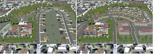
 Examples of a build-out of a site under two different densities and zoning districts from the same viewpoint.
“There will be no more squinting and straining and imagining. Everyone will be able to see the same thing at the same time.” (Mayor Ralph Suozzi, Newsday 31 January 2010)
In December 2009, the City of Glen Cove amended its Municipal Code/Zoning Regulations to require the use of verifiable visual simulations (e.g., verifiable photomontages to photorealistic immersive 3D models of proposed actions) in its land-use review and public decision-making process. The Code amendments, among the first in the country, are based on the Environmental Simulation Center’s report, Using Visual Simulation in the Planning, Review and Permitting Process. The report provided the City with a roadmap as to when, where and how verifiable visual simulation could be used to inform, enhance, and support the decision-making process.
It focused on the procedural steps in the City’s discretionary zoning (e.g., plat and site plan review) and historic preservation reviews and recommends ways that visual simulation tools can be integrated into the public review process to offer officials, citizens, and the applicant clear choices, and help them make informed decisions.
Three primary areas were identified in which visual simulation, such as virtual reality 3D environments, would be appropriate.
- The design phase, including both informal and formal meetings with the Planning Board;
- Public review and hearings by the Planning Board and City Council; and
Specifically, the report addressed
- Communication issues in visualizing and quantifying change to the public and decision-makers;
- The need for verifiability, accountability, and transparency in the public review and decision-making process;
- The capacity of current professional practice and the City to employ visual simulation in the design and decision-making process and their costs; and
The amendment recommends that all pertinent information regarding the project and its context (such as a digital survey, landforms, natural features, trees, wetlands, and existing buildings and structures) be assembled at the beginning of the design and public review process to identify issues and concerns rather than added incrementally as the design review progresses, or at the end in a DEIS. The combination of due diligence, disclosure, and greater transparency, verifiability and accountability through visual simulation has been demonstrated to enhance certainty for both the applicant and the public, reduce exposure to legal actions, expedite the review process, and help create consensus among all involved, leading to better plans and projects and more liveable communities.