
Visioning and Visualization Workshop
The Lincoln Institute of Land Policy, whose mission includes "integrating theory and practice to better shape land policy" and "improving the quality of debate and disseminating knowledge of critical issues in land policy," invited the Environmental Simulation Center and ACP Visioning and Planning to develop a workshop for professional planners on "Visioning and Visualization." The goal of the workshop is to demonstrate the use and importance of simulation and visualization techniques in the planning and visioning process.
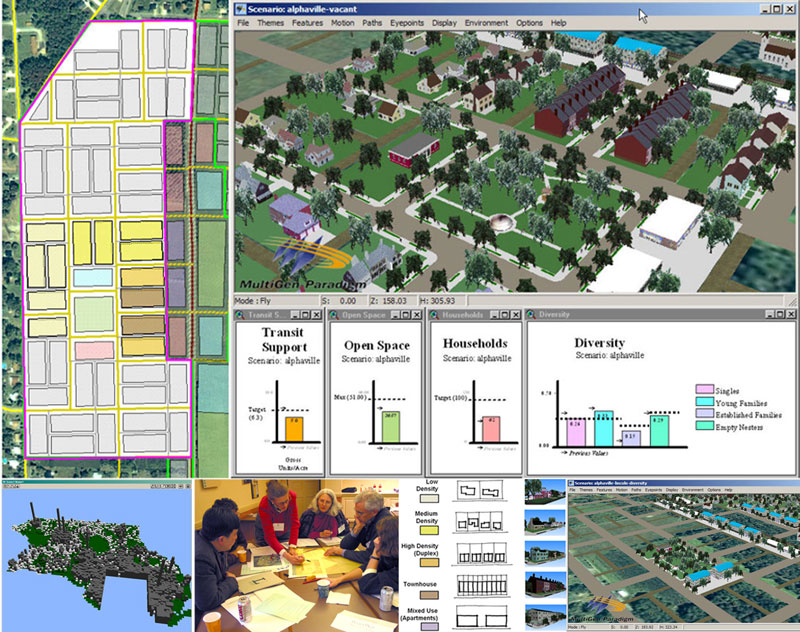
The course begins by explaining the basic concepts of visioning as well as the benefits, challenges and principles for implementing a successful vision. It then gives a critical overview of simulation and visualization techniques that support the visioning process. In the first exercise ("Where Do We Grow?") participants allocate regional growth and density for a hypothetical urban area based on a number of goals, including transit access, open space preservation, and development suitability.
In the second exercise ("How Do We Grow?") groups of participants design different neighborhoods that correspond to regional goals, and experience their designs in an interactive 3D visualization. Participants use a set of 3D "building blocks" which represent a variety of neighborhood development typologies that have attributes regarding land use, demographics of residents, and densities. When assembled, these building blocks provide a composite picture of future development that is not only visually understandable, but also measurable in terms of its impact on community goals. One group's design is then picked for refinement in an iterative process using 3D simulation and impact analysis to evaluate the design as it evolves.
The workshop concludes by reviewing three case studies as well as tools and techniques for implementing a vision that works.